Reading from growth rings and loess layers Ice Age meeting in Budapest
Traces of climate change in stalactites, environmental information preserved in loess, timberline changes in the mountains. The latest results on these topics were presented by Hungarian researchers at the annual meeting of Ice Age specialists in Budapest.
29 March, 2017
Hungarian experts in recent events of historical geology, that is, of the past two million years, discussed the most challenging topics regarding historical climate and environment research with their colleagues from Australia, Great Britain, France, Italy, the United States, China, India and Venezuela. The conference took place at the Hungarian Natural History Museum, and accompanied the annual meeting of the INQUA (International Union for Quaternary Science) leadership. This was the first time that Budapest held this meeting.
New research infrastructure – new possibilities
Hungarian scientists presented several new devices used in their work. One of them is a new accelerator mass spectrometer used for radiocarbon dating, which is capable of handling miniature samples containing fifteen micrograms of carbon. A current R&D GINOP project in the Institute for Atomic Energy Research in Debrecen, Hungary makes it possible to establish a new set of devices which enable scientists to collect data on the time of subsurface runoff, and the usual temperature during the infiltration of these waters. A new member of the research infrastructure will be an ICP-MS mass spectrometer, which helps in the radiocarbon dating of stalactites. Another device to be purchased in the near future will enhance the effectiveness of the analysis of isotopes occurring in carbonate formations. This method will give more exact results on the temperature conditions in the examined period.
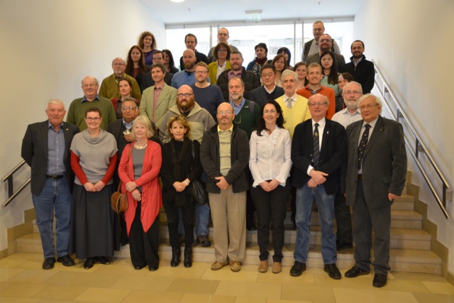 Hungarian and international participants during the INQUA presentation day Source: Ildikó Mészáros
Tales of a stalactite on climate change
Hungarian scientists presented the results they obtained from an analysis of cave formations. With the occurrence of a warm period on Earth 120 thousand years ago similar to the present, the researchers of the Geochemistry and Paleoclimate Research Group working in the Hungarian Academy of Sciences’ Institute for Geological and Geochemical Research outlined the climate changes of this time based on an analysis of a stalactite from the Baradla Cave in Aggtelek, Hungary. The stalactite witnessed a fast change in climate which occurred 125 thousand years ago. Geochemical evidence revealed by an analysis of fluid residues found in the stalactite suggests that in the given period the temperature fell abruptly in the Carpathian Basin, accompanied by an increase in precipitation, especially in wintertime. This event is probably associated with the rearrangement of currents in the north of the Atlantic Ocean, calling attention to the fact that the Atlantic Ocean plays a decisive role in shaping the climate of Hungary and the whole of Europe.
Chronology – thousands of years in growth rings
Huge logs carried by the ice flood of the Tisza River were frequently shown on television this winter. Abrupt floods have always carried away trees; some of these logs were buried in the sediment and emerged later. A joint research group set up by several leading research centres (MTA Institute for Soil Sciences and Agricultural Chemistry, MTA Institute for Geological and Geochemical Research, ELTE, SZTE) is analysing this ancient driftwood. The thickness of growth rings contains information on the changes in temperature and available water during the vegetation period. Hungarian scientists are aiming at reconstructing changes in climate for the longest possible period in the Carpathian Basin with the help of annual rings; this was already done for many European areas in the previous century, spanning several thousand years. The researchers presented the results they obtained from oak and elm driftwood residues that had been collected along the Sajó, Hernád and Mura Rivers.
 The structure of growth rings can be seen very well on the polished butt cross-section of a 6,100–6,300-year-old oak sample. However, the sample is strangely dark compared to fresh oak wood. The wood is tinted by a black precipitation from a chemical reaction between iron compounds dissolved in ground water and the tannin found in oak. Source: Zoltán Kern
Ancient environmental signs in loess
Loess research often yields surprising results. The Carpathian Basin was covered with a dust layer in the dry and cold periods of glaciations. This accumulated dust turned into loess, which was later covered by fertile soil. The loess stratum may be as thick as sixty meters, which makes it suitable for researching the environment and climate of the Ice Age. This field has been researched intensively in Hungary in the past decades and is still today. Soil formation probably began in milder periods of the Ice Age, although these soils were covered with dust in the following period. Besides dating these buried soil strata, other important fields researched by the MTA Institute for Geological and Geochemical Research, ELTE and the Geological and Geophysical Institute include (i) dating the loess strata as precisely as possible, and (ii) comparing the climate information stored in the soil with large scale cooling and warming periods of the North Atlantic Region, which occurred every 1,000–1,500 years. Owing to these climate changes, the flora of the Carpathian Basin seems to have changed between mosaic conifer forest steppe and steppe tundra environments. The changes matched the changes in the North Atlantic Region, though not every change in climate initiated a decisive environmental shift in the Carpathian–Pannonian Region.
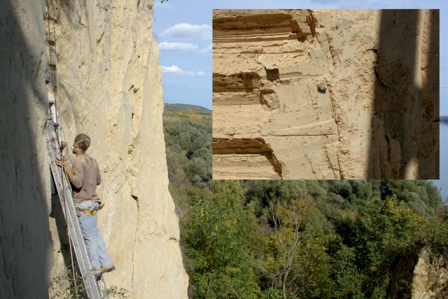 Loess wall profile near Dunaszekcső, Hungary. This profile seems to have the most exact chronology in the world owing to the radiocarbon dating of several hundreds of charcoal and terrestrial snail shell residues buried in the loess wall. The dust deposition rate here correlates well with the deposition rates detected with the help of Ca2+ in the Greenland NGRIP ice profile and the cold-warm fluctuations detected with the help of stable isotopes.
Tree line and climate change
Tarns in the Southern Carpathian Mountains are often visited by Hungarian hikers. One of the most beautiful mountain ranges there is the Retezat. Lakebeds here were formed by glaciers in the Ice Age, and the lakes emerged after ice disappeared approximately 15 thousand years ago. These tarns contain the residues of trees growing around the lake, the chitin exoskeletons of non-biting midges (Chironomidae), pollen settled from the air and the frustules of diatoms living in the lake. With the help of these residues, scholars can reconstruct the ancient environment of tarns, including changes to timberline and tree line.
One of the most spectacular changes induced by rising temperatures witnessed in our region is that the timberline and the tree line are moving upwards in several mountain regions of Europe. How has this changed in the past 15 thousand years? This is the question scientists of the MTA-MTM-ELTE Research Group for Paleontology wish to answer in collaboration with scholars from the Environment and Landscape Geography Department. They proved that 3,000 years ago the timberline in the Retezat Mountains used to be 100-150 meters higher than today. Has it changed due to human activity or climate change? Studies similar to this claim that 3,000 years ago in the Alps the phenomenon was caused by grazing at high altitudes and accompanying deforestation. However, they also indicate the cooling of the climate 6,000 years ago as among the important causes.
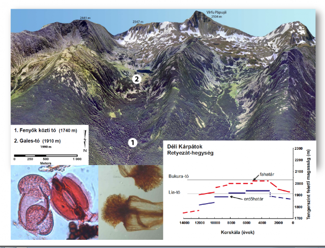 (Top) The location of the tern sediment sections used to reconstruct changes in the height of the timberline and tree line on the northern slope of the Retezat Mountains.
(Bottom left) Pollen and guard cell of the stoma of creeping pine (Pinus mugo) preserved in the sediment.
(Bottom middle) The male flower of creeping pine (Pinus mugo) is often found among plant macrofossils.
(Bottom right) This and other similar fossils were used for the reconstruction of changes in the height of the timberline and tree line over the past 14-15 thousand years.
This research in the Carpathian Mountains has only started recently. Climate change, especially the abrupt 1.5 centigrade drop in mean summer temperature about 3,000 years ago, has played a crucial role in the lowering of the timberline here as well. Human activity furthered this natural process: at first humans only exploited the abundant high mountain regions spotted with meadows. The sediment in high mountain tarns contains traces of human deforestation only from the second half of the Iron Age.
For further information please contact:
Enikő Magyari
scientific advisor
MTA-MTM-ELTE Palaeontology Research Group
emagyari [at] caesar [dot] elte [dot] hu